Maps and Directions - Brooklyn Bridge Park Skip To Content Privacy Page

Park Alerts & Updates Learn More

Donate to Conservancy Programs
Support
Open Map
Dec

15

29°F

Sunrise
07:13 AM
Sunset
04:29 PM
Tide

HIGH 1:40 AM


Low 7:55 AM

Park Hours and Info

Park is Open 7 Days a Week | 6AM - 1AM
Entry is Free!

Pier 28AM - 9PM* Pier 56AM - 11PM* Education Center3-5PM (THU/FRI), 1-5PM (SAT) Pier 6 Volleyball Courts6AM - 11PM Playgroundssunrise-sunset
Plan Your Visit

Maps and Directions

Our Park Map will show you all the Piers and Sections within Brooklyn Bridge Park.

GETTING TO THE PARK

Parking near Brooklyn Bridge Park is very limited. We highly recommend taking public transportation, biking or walking to the park. BBP is accessible by bus, subway and ferry.

Bus

  • B25 Fulton Ferry Landing
  • B63 Loop road on Pier 6
  • B61 Atlantic Ave. & Hicks St.
  • B67 Jay St. & York St.

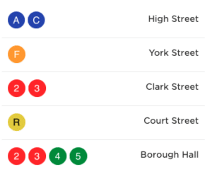
Subway

Ferry

Finding the Best Route to the Park

BIKING

Visit our biking page for directions and more resources. Many Citibike docks are located near Park entrances.

ACCESS-A-RIDE

To enter the Park at Pier 1, please use the address 1 Water Street (corner of Old Fulton and Water Street at Fulton Ferry Landing). To enter the southern end of the park, please use the address 360 Furman Street and exit on the west side of the building (intersection of Furman Street and Bridge Park Drive).

PUBLIC PARKING FACILITIES

Limited metered spaces are available in the parking lot on Furman Street near Pier 2. Paid parking lots are available under Squibb Bridge with Laz Parking and at Pier 6, located on the south side of 360 Furman Street.

SCOOTER SHARE

Please note that scooter shares are not allowed to be ridden within Brooklyn Bridge Park. Please check the programs parking requirements in advance.

FAQs

20,000

participated in environmental education programs

Explore

365

Days Open Per Year

Explore

3,000

Trees in the park

Explore

Sign Up For Our
Newsletter

This field is for validation purposes and should be left unchanged.